
If you like what I am doing please click here to donate to my chosen charity.
Total Distance: 25 Miles

Highest Point: 2415 Feet

Total Realistic Time: 11 Hours
“The mountains of Whernside (736 m or 2,415 ft), Ingleborough (723 m or 2,372 ft) and Pen-y-ghent (694 m or 2,277 ft) are collectively known as the Yorkshire Three Peaks. The peaks, which form part of the Pennine range, encircle the head of the valley of the River Ribble in the Yorkshire Dales National Park in the North of England.”
– https://en.wikipedia.org/wiki/Yorkshire_Three_Peaks


Main car park with toilets £5 for the day (please check before travelling as this may have changed):
The Yorkshire Dales National Park Authority
Horton-in-Ribblesdale Yorkshire Dales National Park Centre
B6479
North Yorkshire
Horton-in-Ribblesdale
BD24 0HF
There are also free layby areas if you get there early enough and also farmers fields are sometimes open when it is busy (charges may apply).
We travelled from Morecambe to Horton-in-Ribblesdale which took about 1 hour. Arrived at 6:15am, it was busy already with many event groups ready to go.
A good breakfast (good slow release fuel I recommend is porridge and banana) is recommended before starting, to give you plenty of fuel to get you up that first hill. Started walk from Horton-in-Ribblesdale to the first hill Pen-ye-ghent – this one was a straight up path towards the top. Hard work to start with which warmed you up.


Then the path dips down pretty steep taking you towards the next hill Whernside. This was harder work to the top as it was a long, very long it seemed, gradual uphill climb before you get to the top. There is a path all the way there. Stopped halfway to fuel up with sandwich. It turned out to be a very hot day, hydration was important, we had with us a 500ml flask that included water with added High 5 Zero Hydration Tablet – Berry flavour that replenishes the salts and minerals lost during the hike to keep your body hydrated and also additional 2 litres of water.


Once you get to the top of Whernside – the views were amazing. The weather was beautiful – sun shining, not too hot and not too cold, no rain as it was forecasted for part of the day.
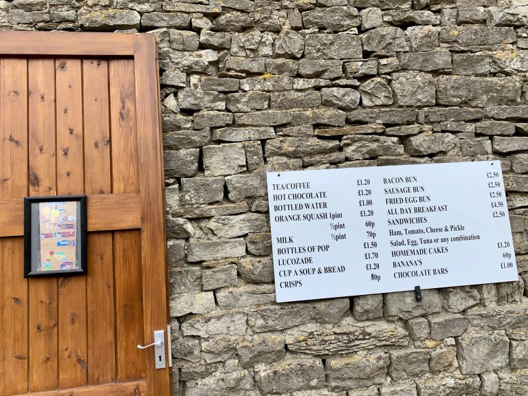
From Whernside towards the last hill Ingleborough, there is a very good snack bar with toilets, they serve a good selection of cold and hot food along with coffee or tea. A welcome break to get good fuel before tackling the final hill.


It was a hard gradual ascent up, as it was also pretty busy on the day. You look up where you had to climb and it looked pretty steep with people coming down and people going up on a single track. A quick hydration and snack stop we carried on and tried not to look up as it looked very steep, just kept the feet moving with some sections you had to do a bit of scrambling. When you thought you got to the top, you look up and there is another steep climb up, again quick hydration and snack, then avoiding looking up and keeping the feet moving to get to the top.

It was nice to see it was flat up there and a short little walk further to Ingleborough summit point. The view was pretty clear and amazing.


The last part coming back down was not too bad, not as bad as coming down from Pen-y-ghent as that was fairly steep and felt long.
Last part heading back to Horton-in-Ribblesdale was enjoyable, did a bit of running down the hill to help the knees and experience a bit of trail running.


It was a great sense of achievement and we did it in 11 hours – better time than we thought. Fantastic challenge well worth the effort.
I would recommend training for it and also take hiking poles to help support the knees in sections where it was quite steep going down.
Go on challenge yourself.
GENERAL EQUIPMENT
- Apple iPhone XS (for use of OS apps for lazy mapping)
- OS Maps app (signed up to 1 year auto renew at £19.99 to use the app with OS Explorer Map 1:25k – click here for more info)
- Gaia Maps app (free version – I use for tracking walk)
- Comfy walking shoes (most important)
- Extra socks (keep the feet happy when needed)
- Waterproof Jacket (always a must, the weather changes alot in the hills/mountains)
- Long sleeve and/or short sleeve (for layering)
- Neck scarf (extra warmth and protection if needed)
- Gloves (if scrambling is required)
- 2 litres of water
- Flask with water and hydration tablet (High 5 Zero Hydration Tablet – Berry Flavour)
- ibuprofen (helping hand if you have any aches and pains)
- Food and snacks (fuel to keep you going)
- Cash (handy for the snack bar)